The River and The Wall
by Ben Masters
Ben Masters (@bencmasters) is a wilderness guide, filmmaker, and author currently based in Austin, Texas. He directed and wrote The River and The Wall, a recently released documentary and book chronicling a three-month expedition down the Rio Grande, during which he interviewed border patrol agents, immigrants, landowners, wildlife biologists, representatives on both sides of the American political aisle, and those who call the banks of the Rio Grande home.
Santa Elena, Mariscal, Boquillas… For those of us lucky enough to have paddled through these monumental cathedral canyons, which cradle the Rio Grande as it skirts the southern boundary of the United States, simply hearing their names engenders a yearning to float down the river and marvel at the magnificence of a landscape that seems to defy gravity, rivaling the Grand Canyon in its grandeur. Further downstream, the river nourishes some of the most biologically diverse and ecologically important landscapes in North America. The border you hear about in the media is different than the border that I know.
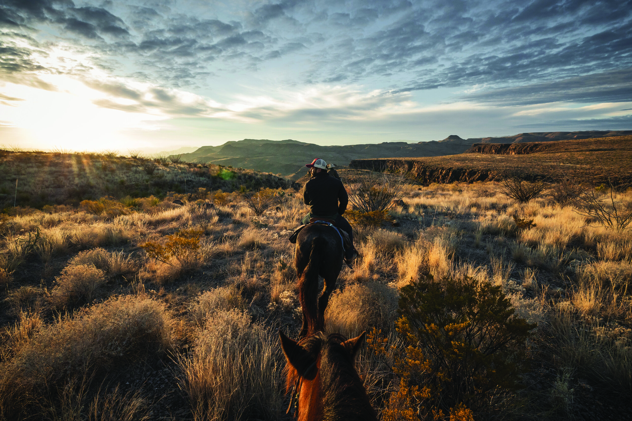
As a native Texan, I’ve spent much of my life exploring the Rio Grande, where I have managed a 4,000-hectare game park outside Laredo, guided aoudad hunts in far West Texas, and pitted my white-water rafting skills against some of the most remote, wild, and scenic river stretches North America has to offer. For me, talk of building a border wall is personal, as it would take a devastating toll on the landscapes I cherish and have a long-lasting impact on wildlife dispersal, genetic exchange, and habitat loss.
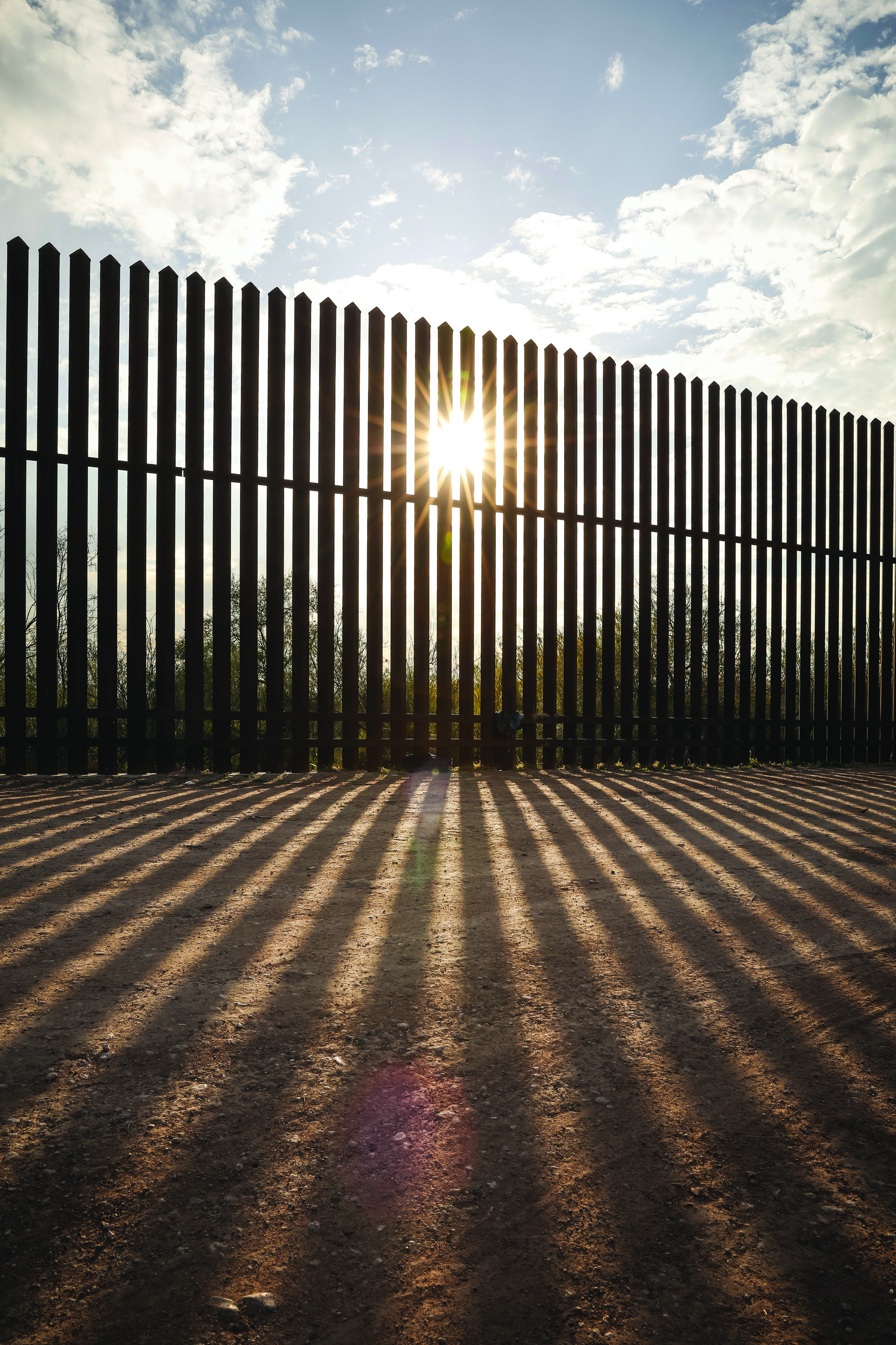
It is important to note that a “wall” or fence currently exists along much of the 3,218-kilometer U.S.–Mexico border. As of this writing, some 1,050 kilometers of physical barrier have been erected, most of it built in California, Arizona, and New Mexico in 2006 and 2007 under the Bush administration’s Secure Fence Act, the aim of which was to address potential national security weaknesses in the wake of the 9/11 terrorist attacks. The most formidable barriers—six-meter-plus-high fences built of concrete and steel—have been built in urban areas such as where San Diego borders Tijuana, while rural area borders tend to be protected by steel “Normandy” fences, which block vehicle passage while still allowing for a free flow of wildlife and folks on foot. In Texas, however, the border is different from the other states because the actual boundary is the constantly changing Rio Grande, the fourth longest river in North America. Thus, the border wall has to be built on American soil above the floodplain and in logistically feasible terrain. Currently, there is a 110-kilometer stretch of border wall separating El Paso and its suburbs from Juárez, Mexico, along with another approximately 100 kilometers of wall near the terminus of the river in the Lower Rio Grande Valley. More than 1,600 kilometers of the Texas-Mexico border remain free of a border wall. Those 1,600 kilometers include Texas’s largest national park, largest state park, largest wildlife management area, the only stretch of congressionally designated Wild and Scenic River, numerous wildlife refuges, and more than 2,000 parcels of private property owned by Texans who aren’t thrilled about the federal government seizing their land for a wall.
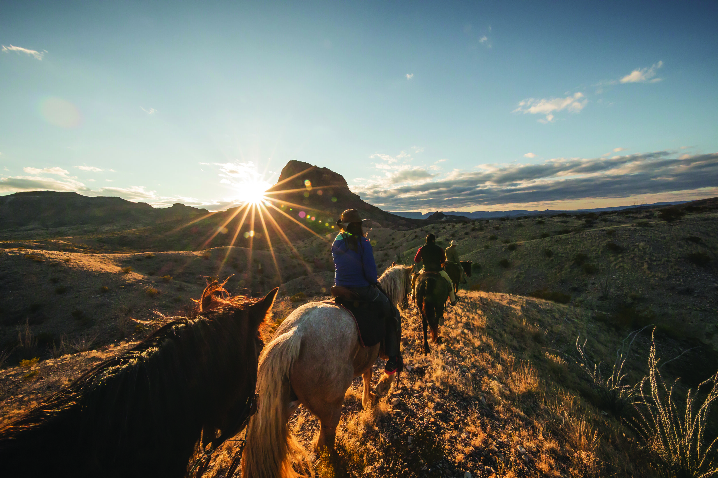
Since 2016, I have been photographing and filming these beloved landscapes not only to show others what a wall would be built through, and the ecological consequences of its construction, but also to document these landscapes for the historical record before a wall is constructed through them. Already, some of the landscapes we’ve captured have been bulldozed for border wall construction. In order to see the entirety of the border, I brought together four friends in early December 2017 and together we embarked on a three-month, 1,930-kilometer journey along the river, traveling from El Paso to the Gulf of Mexico, using mountain bikes, my mustangs, and canoes to document and observe these epic, at-risk landscapes with our own eyes. Along the way, we also had the chance to interview wildlife biologists; border patrol agents; American politicians on both sides of the aisle; asylum seekers; local ranchers; and everyday Joes living in both Mexico and the United States. We have since chronicled our journey in a recently released book and documentary film, both titled The River and the Wall. What follows are a few of our environmental observations.
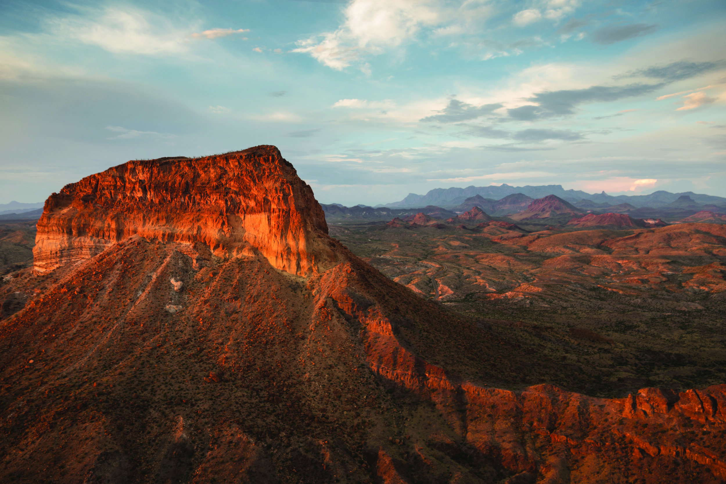
The existing border wall ends 110 kilometers downstream of El Paso where the terrain becomes mountainous and broken. For the next 160 or so kilometers, the area is known as the Forgotten Reach because there’s little to no water in the Rio Grande due to upstream dams and diversions. The nearest 4WD road is often well north of the border and if a wall were to be constructed here, tens of thousands of hectares would be stranded between the river and the wall due to the geographical constraints of suitable construction sites. The landscape is a remarkably rugged, cactus-infused, aoudad-infested, steep, broken mountain range. It is impossible to see how a man-made wall could be more difficult to cross than this wilderness. The Forgotten Reach ends at the border town of Candelaria and for the next 80 kilometers to Presidio, there’s a gravel road that turns to asphalt, which travels next to the river.
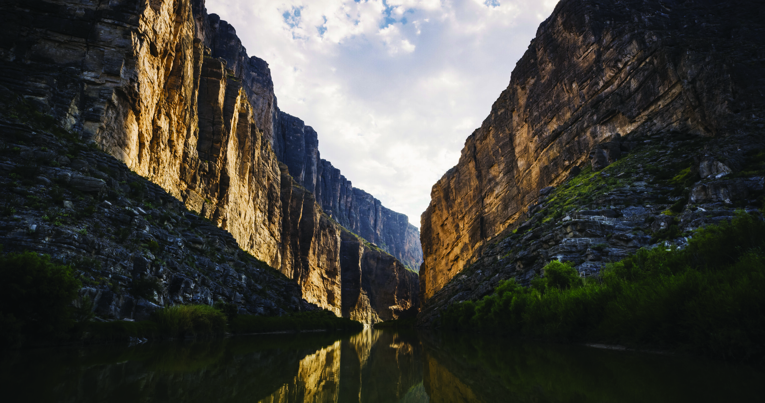
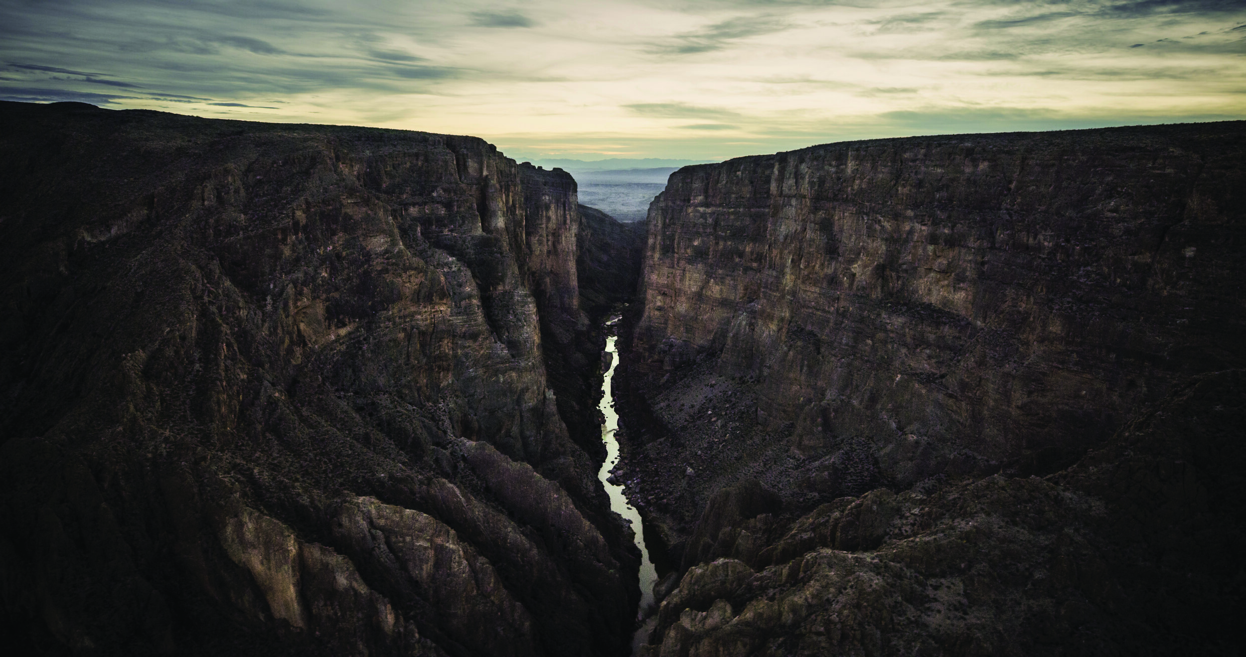
In Presidio, the Rio Conchos, flowing north out of Mexico, enters the Rio Grande and brings the river back to life as it enters Big Bend Ranch State Park, a 134,000-hectare gem of a recreation area, and Big Bend National Park to the east. Compared to other Border Patrol sectors, this area sees few illegal crossings and little drug-smuggling activity. Yet I believe the possibility of a border wall being built here is real, primarily because much of Big Bend is public land. Highway 170, the most beautiful drive in the state of Texas, parallels the Rio Grande through these parks before swinging north, away from the river, when it hits Mesa de Anguila in Big Bend National Park. It is here that the truly massive canyons begin, those of Santa Elena, Mariscal, and Boquillas.
Every year, hundreds of thousands of tourists visit Big Bend National Park to paddle the river, soak in its hot springs, or cross into Mexico for a taco and a beer. Entire communities of river guides and thousands of people’s livelihoods depend on the tourism that the park and the river provide. While a border wall is lunacy where there are 300-meter-high canyons, there are gaps between the canyons where roads exist and a border wall could be built, a move that would surely kill the area’s tourism and damage the psyche of many Texans who love Big Bend because it is our state’s only large public-land playground.
Perhaps more important, building even small segments of wall here would have a devastating impact on wildlife, reversing some of the most important conservation gains in recent decades, gains achieved largely through the collaborative efforts of NGOs, landowners, and government agencies on both sides of the border. Desert bighorn sheep have been recently reintroduced and are thriving after being eliminated from the state. Black bears have returned after their extirpation as a result of a lone female crossing the river from Mexico in the late 1980s, not to mention healthy populations of mountain lions for which this region is known. There are more than 400,000 hectares of protected public lands in Texas and 800,000 hectares of protected lands in Mexico flanking a 300-kilometer stretch of the river. It should come as little surprise that more than 80 years ago, Franklin D. Roosevelt proposed the creation of a binational park between Mexico and the United States similar to Waterton-Glacier International Peace Park on the U.S.-Canada border. If created, such an international park would be one and a half times the size of Yellowstone, equally magnificent, and far more biologically diverse (see page 34).
Beyond these federal protections, the river’s legendary white-water rapids are also protected under the National Wild and Scenic Rivers Act of 1968. Under normal circumstances, such a Wild and Scenic designation would prohibit large federal construction projects within a kilometer of the river, but under special provisions in the Secure Fence Act, the Department of Homeland Security can waive all environmental, cultural, and local stakeholder safeguards to allow for border wall construction. In the words of Republican Congressman Will Hurd of Texas, who represents this district, “You have the Rio Grande, you have canyons, and you have the Chihuahuan Desert. Building a wall here in Big Bend, that’s just crazy.”
Downstream of the Texas river canyon country, the dam at Lake Amistad (Spanish for friendship) impounds the Rio Grande, Pecos, and Devils River. The reservoir is famous for its clear water, renowned bass fishing, and Native American rock art. Below Lake Amistad, the Rio Grande is cold, crystal clear, and bursting with smallmouth and largemouth bass. In the winter, every bend in the river is greeted with hundreds of thousands of waterfowl, especially bufflehead, wigeon, and teal. Huge flocks of white pelicans fly up and down this stretch of the Rio Grande where the landscape becomes somewhat tropical. Mixed in with the oaks cresting limestone hills, native palms begin dotting the riverbank and Spanish daggers crest the horizon lines.
It’s a beautiful part of the border with sister communities on both sides of the river. In Del Rio and Eagle Pass, a border wall currently exists in the urban areas. In the rural areas, however, Border Patrol has installed camera towers on hilltops and employed blimps for surveillance of people crossing illegally. The border wall here has had limited impact on wildlife and its habitat simply because it is confined to urban areas, although it does restrict access to the Rio Grande and historic parks. In Eagle Pass, for example, there are soccer fields, municipal parks, and fishing areas on the Mexican bank whereas on the American side the wall blocks public access to the river, upon which the community was founded.
For a continuous wall to be constructed along this section, it would have to transit some of the largest and most historic ranches in Texas, whose wealthy and powerful landowners are not thrilled about the federal government seizing their private land to build a wall that would block them from the river. This big ranch country is wild as hell in parts, with very low population density, huge white-tailed bucks, and only one “main” road, the Mines Road, which is closed off to the public.
As one enters Laredo further downstream, the wild ranch country gives way to urban sprawl on both sides of the Rio Grande. Laredo is one of the few metropolitan areas that does not have a continuous wall along the river. Instead, it has a large municipal park on the riverbank, a vital part of its historic district. South of Laredo, the river flows through a patchwork of small communities, farms, and ranches for 60 or so kilometers before entering Lake Falcon.
For simplicity sake, I consider the stretch of river from Lake Falcon to the Gulf of Mexico as the Lower Rio Grande Valley. The word “valley” though isn’t accurate because it’s actually a delta. Historically, before the Rio Grande was dammed and diverted so much upstream, the river flooded this delta annually, creating oxbow lakes that breathed life into one of the most biologically diverse subtropical ecosystems in the continental United States.
Today, less than 5 percent of this incredible Tamaulipan thornscrub habitat is left due to habitat loss, fragmentation, agriculture, and urbanization. The ecological importance of the habitat that remains cannot be understated. The birding is so outrageous that the World Birding Center is located a short walk from the Rio Grande adjacent to Bentsen-Rio Grande Valley State Park. For decades, private and public conservation entities have endeavored to create a wildlife corridor along the Rio Grande, given its importance as a wintering habitat and stopover point for birds, bats, and butterflies on a continental scale. The Nature Conservancy, Audubon Society, Texas Parks and Wildlife, National Butterfly Center, and U.S. Fish and Wildlife Service, as well as numerous private entities, have invested tens of millions of dollars in habitat conservation along the border to create a string of pearls of protected lands along the Rio Grande for native wildlife.
Visiting this region is like stepping into the tropics and the chorus of birds is overwhelming. Altamira orioles exalt their beautiful birdsong; chachalacas give raspy cries in the morning dawn; and green jays battle for territory under a canopy of dense trees. Bird-watchers flock to the area to see species that can be found nowhere else in the United States, while thousands of school kids come here annually to learn about the natural world. Yet this sector also sees the highest amount of unauthorized border crossings along the entire U.S.-Mexico border. There have been times when the Border Patrol has apprehended more than 1,000 unauthorized migrants in a single day. Despite its biological diversity and fecundity, it is ground zero for the wall.
In 2018, $1.6 billion was allocated for border wall construction, much of it focused on the Lower Rio Grande Valley. The border wall here is slated to be built primarily on a system of levees outside of the floodplain. In some areas, these levees would be near the Rio Grande, in others they will be a kilometer or two inland. The Department of Homeland Security has already begun clearing land for the enforcement zone and some of your National Wildlife Refuge was bulldozed in March of this year. While some of the notable conservation areas such as the Santa Ana National Wildlife Refuge and Bentsen-Rio Grande Valley State Park have so far been spared, this could change if the current American president is successful in freeing up further wall funding through a National Emergency declaration.
As an outdoorsman who has traveled every kilometer of the Rio Grande from El Paso to the Gulf, it is infuriating to hear people refer to my beloved backyard as an expendable black line on a map, seemingly indifferent to what would be lost. The Rio Grande is a river before it is a border, a vital waterway that nourishes some of the most biologically diverse habitat on the North American continent. It pains me to think that I might be among the last to behold the grandeur of the landscapes sculpted by the Rio Grande before a border wall mars them forever. It’s been an honor and a privilege to document this incredible watershed, and I invite every interested reader to come and see the border firsthand. It’s safe, the people are welcoming, the culture is vibrant, and the flora and fauna rivals anything in the United States.